
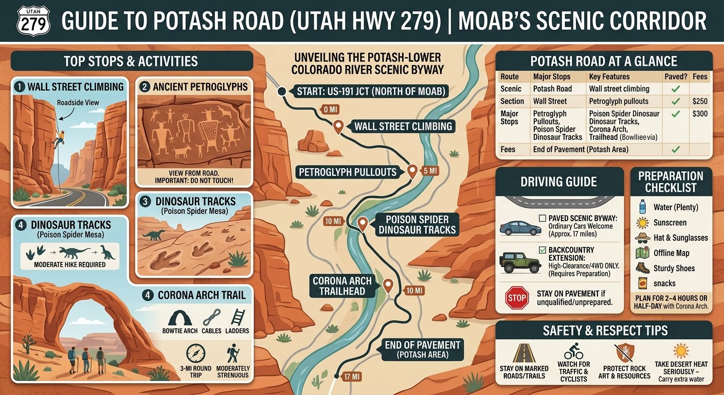
If you’re looking for an easy scenic drive near Moab, Potash Road Moab is one of the most rewarding options. Utah Highway 279, officially the Potash-Lower Colorado River Scenic Byway, follows the Colorado River for roughly 17 miles past towering sandstone cliffs, ancient rock art, dinosaur tracks, climbing areas, and the Corona Arch trailhead. The paved scenic section can be driven in a regular passenger vehicle, although some trails and roads beyond the pavement require different equipment.
Quick Answer: Potash Road is a roughly 17-mile scenic drive west/southwest of Moab along the Colorado River. Allow about 2–4 hours if you plan to stop at the petroglyphs, dinosaur tracks, viewpoints, or Corona Arch. The paved scenic section is accessible to ordinary vehicles.
Potash Road Moab at a Glance
| Detail | What to know |
|---|---|
| Route | Utah SR-279 / Potash Road |
| Scenic section | About 17 miles |
| Starting point | US-191, north of Moab |
| Main scenery | Colorado River and red-rock canyon |
| Major stops | Wall Street, petroglyphs, dinosaur tracks, Corona Arch |
| Driving style | Scenic out-and-back |
| Paved section | Yes |
| Hiking option | Corona Arch |
| Off-road extension | Requires appropriate vehicle and experience |
| Fees | Many roadside attractions are on BLM land and have no entrance fee |
Utah tourism describes the route as the Potash-Lower Colorado River Scenic Byway and lists its major attractions as sandstone cliffs, the Colorado River, dinosaur tracks, petroglyphs, arches, and climbing routes.
Where Is Potash Road in Moab?
Potash Road begins off US-191, approximately four miles north of central Moab. From town, drive north on US-191 and look for the turn onto UT-279.
The Bureau of Land Management gives the same basic access: from Moab, head north on US-191 and turn onto Potash Road.
Once you’re on UT-279, the landscape changes quickly. The route follows the Colorado River into a narrower canyon, with massive sandstone walls becoming the dominant feature.
This is one reason the drive works so well for first-time visitors: you don’t need to commit to a long backcountry excursion to experience classic Moab scenery.
How Long Does Potash Road Take?
The paved route is approximately 17 miles one way. Driving without stopping doesn’t take very long, but that’s not really the point of the road.
For a sightseeing trip, plan on:
- 1 hour: Drive out and back with very few stops.
- 2 hours: Scenic drive with several roadside stops.
- 3–4 hours: Petroglyphs, dinosaur tracks, viewpoints and longer stops.
- Half a day: Add the Corona Arch hike or another substantial activity.
Discover Moab lists the byway itself at 17 miles and about one hour as a basic route estimate, while other local guides recommend considerably more time when stops and hikes are included.
So don’t judge Potash Road by its mileage alone. The attractions are what make the drive worthwhile.
Best Stops on Potash Road
The easiest way to explore Potash Road is to treat it as a sequence of short experiences rather than one continuous drive.
1. Wall Street Climbing Area
One of the first major visual highlights is Wall Street, where enormous sandstone cliffs rise directly beside the road.
The area is famous for roadside rock climbing. Even if you never touch climbing equipment, it can be fun to pull over and watch climbers working their way up the sandstone.
The important thing is to stay aware of traffic and climbing activity. Do not walk beneath active climbing routes or interfere with ropes and equipment.
The BLM identifies Wall Street as one of the recreation opportunities within the Colorado Riverway area.
2. Potash Road Petroglyphs
The petroglyph panels are among the most important reasons to slow down on this drive.
Several panels can be viewed from marked roadside pullouts. The Canyonlands Natural History Association notes that some of the rock art is located approximately 15–20 feet above the road and that additional panels can be found farther along the route.
Don’t touch, climb on, or trace the markings.
The BLM specifically warns visitors not to touch petroglyphs because oils from human hands can contribute to damage over time.
These aren’t simply decorative roadside drawings. They are cultural resources, so viewing them respectfully is part of visiting the area responsibly.
3. Poison Spider Dinosaur Tracks
Continue along Potash Road toward the Poison Spider Mesa area and you’ll find another unusual attraction: dinosaur tracks.
The BLM identifies the Poison Spider Mesa Trailhead as a location for hiking, mountain biking and OHV recreation, with the dinosaur tracksite accessible from Potash Road.
From Moab, the BLM directions place the trailhead roughly six miles along Potash Road before turning toward the Poison Spider area.
This makes the dinosaur tracks an especially good stop for families or anyone interested in geology and paleontology.
Bring sturdy footwear if you’re planning to leave the roadside and explore uneven terrain.
4. Corona Arch Trail
If you have time for one substantial hike, Corona Arch is the major addition to your Potash Road itinerary.
The BLM describes the Corona Arch Trail as a moderately strenuous 3-mile round trip. The route includes sections with cables and ladders to help hikers negotiate exposed terrain.
The trailhead is reached directly from UT-279, making it an easy addition to a scenic-drive day.
You’ll also see Bowtie Arch along the hike.
The hike isn’t technically part of the scenic drive itself, so allow additional time rather than trying to squeeze it into a quick roadside stop.
What should you know before hiking Corona Arch?
Expect:
- Slickrock terrain
- Uneven surfaces
- Some exposure
- A ladder
- Safety cables
- Desert heat and limited shade
- A roughly 3-mile round trip
The BLM says there is no fee for hiking Corona Arch and asks visitors to stay on the established trail and help protect the heavily used route.
5. Colorado River Views
The road’s greatest attraction may simply be the river itself.
For much of the route, Potash Road runs between the Colorado River and towering red-rock cliffs. The combination creates a very different experience from driving through the open desert around Moab.
Stop at designated pullouts rather than creating your own parking spot.
This is also a good place to slow down and photograph the contrast between green river vegetation, blue water and orange sandstone.
6. Potash Boat Ramp
The paved scenic route eventually reaches the Potash area and boat ramp.
The BLM identifies the Colorado Riverway as an area supporting boating, rafting, hiking, climbing and other recreation. Gold Bar Recreation Site, farther along the corridor, also provides river access and camping facilities.
At this point, remember that Potash Road is primarily a scenic paved route. Roads continuing into the backcountry are a different proposition.
Can You Drive Potash Road in a Regular Car?
Yes, for the paved scenic portion of UT-279.
This distinction is important because online descriptions sometimes combine Potash Road with nearby 4WD routes.
The paved Potash Road scenic drive is suitable for ordinary passenger vehicles. You do not need a Jeep simply to visit the main attractions along UT-279.
However, do not assume that every road beyond the paved section is equally easy.
Some nearby backcountry routes lead toward the Shafer Trail and Canyonlands area and require appropriate high-clearance or four-wheel-drive vehicles depending on the specific route and current conditions.
If you’re driving a rental sedan, stay on the paved scenic portion unless the rental agreement and road conditions explicitly allow anything else.
When Is the Best Time to Drive Potash Road?
Spring and fall are generally comfortable seasons for exploring Moab’s outdoor attractions, particularly if you’re combining the drive with hiking.
Summer can still be beautiful, but desert temperatures make midday hiking considerably more demanding.
For photography, morning and late afternoon can provide attractive light on the canyon walls. A local Moab route guide also recommends early or late in the day for softer light and fewer distractions.
A simple timing strategy
Morning:
Drive Potash Road and stop at the rock art and dinosaur tracks before tackling Corona Arch.
Afternoon:
Hike Corona Arch earlier, then take the scenic drive afterward.
Late afternoon:
Drive the route specifically for scenery and photography.
Always check current conditions before heading out, especially after storms or during periods of construction or maintenance.
What to Bring on Potash Road
Even though the paved drive is close to Moab, don’t treat it like a city sightseeing route.
Pack:
- Plenty of drinking water
- Sunscreen
- Sunglasses and a hat
- Comfortable walking shoes
- Snacks
- Offline maps
- Camera or phone
- Binoculars for distant rock features
- Extra water if you’re hiking
There are no shops or fuel stations along the scenic route, so take care of basic supplies in Moab before leaving.
Cell coverage can also be inconsistent in canyon country, making an offline map a useful backup.
Potash Road Safety Tips
A few simple habits make the trip much easier.
Stay on marked roads and trails
The desert can look deceptively open. Don’t assume an unmarked track is safe or legal simply because another vehicle has used it.
Watch for traffic
Potash Road is a real state highway, not a closed scenic loop. Cyclists, trucks, climbers and other visitors all use it.
Protect the rock art
Never touch or climb on petroglyph panels.
The BLM specifically asks visitors not to touch the inscriptions.
Take heat seriously
A short desert hike can become uncomfortable quickly in summer. Carry more water than you think you’ll need.
Be careful around climbing areas
At Wall Street, watch where you walk and stay clear of active climbing routes.
Is Potash Road Worth Visiting?
Potash Road is particularly useful for travelers who want to experience several different sides of Moab without spending an entire day inside a national park.
In a relatively short corridor, you can see:
- Colorado River scenery
- Red-rock canyon walls
- Historic rock art
- Dinosaur tracks
- Rock climbing
- Natural arches
- Hiking trails
- River recreation
- Potash mining landscapes
The route also gives you flexibility. You can spend an hour on the drive or turn it into a half-day outing by adding Corona Arch and several stops.
And unlike a destination where the attraction is located at one endpoint, much of the experience happens along the road itself.
Potash Road vs. a Typical Moab Park Day
If you’re planning a short Moab visit, it helps to understand what kind of experience Potash Road provides.
| Potash Road | National Park Visit |
|---|---|
| Scenic road with multiple stops | Destination-focused |
| Colorado River views | Monumental park scenery |
| Petroglyphs and dinosaur tracks | Park trails and overlooks |
| Corona Arch outside the national parks | Famous park arches/canyons |
| Flexible timing | Often requires more itinerary planning |
| Many attractions close to the road | Often involves longer hikes or drives |
This doesn’t make one experience universally preferable. They simply serve different travel plans.
Potash Road is particularly convenient when you have a few hours to fill between other Moab activities.
A Simple Potash Road Itinerary
For first-time visitors, this straightforward plan works well:
1. Start in Moab
Fill your vehicle with fuel and water.
2. Take US-191 north
Follow the road toward the UT-279 junction.
3. Turn onto Potash Road
Begin following the Colorado River corridor.
4. Stop at Wall Street
Watch the climbers and take in the sandstone cliffs.
5. Visit the petroglyph pullouts
Use the marked parking areas and observe the panels without touching them.
6. Continue toward Poison Spider
Look for the dinosaur track area and interpretive information.
7. Hike Corona Arch if time allows
Allow several hours if you’re including the complete hike at a relaxed pace.
8. Continue toward the end of the paved route
Enjoy the changing canyon and river scenery.
9. Turn around and return to Moab
The return journey offers different views of the canyon.
FAQ: Potash Road Moab
How long is Potash Road in Moab?
The scenic paved portion of Potash Road, or Utah SR-279, is approximately 17 miles from its junction with US-191 toward the Potash area.
Is Potash Road paved?
Yes. The main Potash-Lower Colorado River Scenic Byway is paved. Don’t confuse that paved scenic route with nearby backcountry roads that continue beyond it.
Can you drive Potash Road in a regular car?
Yes. A normal passenger vehicle can handle the paved scenic portion. The need for a high-clearance or 4WD vehicle applies to certain backcountry routes rather than the basic scenic drive.
What are the best stops on Potash Road?
Popular stops include Wall Street, Potash Road petroglyphs, Poison Spider dinosaur tracks, Corona Arch and Colorado River viewpoints. The BLM specifically identifies Corona Arch, Wall Street and Poison Spider Mesa among the area’s recreation opportunities.
How far is Corona Arch from Potash Road?
The Corona Arch trailhead is directly accessed from UT-279. The BLM directions place it about 10 miles along UT-279 from US-191.
Final Thoughts
Potash Road Moab is a compact way to experience the variety that makes the Moab area famous. In roughly 17 miles, the route combines the Colorado River, giant sandstone walls, rock art, dinosaur tracks, climbing and access to one of the area’s most memorable hikes.
The key is not to rush it. Give yourself at least a couple of hours for the scenic drive, and more if you want to hike Corona Arch.
